


Dover township voting district 12, Ocean County, New Jersey
About
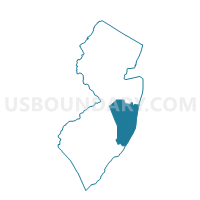
Outline

Summary
| Unique Area Identifier | 621447 |
| Name | Dover township voting district 12 |
| County | Ocean County |
| State | New Jersey |
| Area (square miles) | 5.24 |
| Land Area (square miles) | 0.31 |
| Water Area (square miles) | 4.93 |
| % of Land Area | 5.97 |
| % of Water Area | 94.03 |
| Latitude of the Internal Point | 39.96785670 |
| Longtitude of the Internal Point | -74.11235540 |
Maps


Graphs
Select a template below for downloading or customizing gragh for Dover township voting district 12, Ocean County, New Jersey


Neighbors
Neighoring Voting District (by Name) Neighboring Voting District on the Map
- Brick township voting district 10, Ocean County, NJ
- Brick township voting district 19, Ocean County, NJ
- Brick township voting district 26, Ocean County, NJ
- Brick township voting district 44, Ocean County, NJ
- Brick township voting district 55, Ocean County, NJ
- Dover township voting district 17, Ocean County, NJ
- Dover township voting district 20, Ocean County, NJ
- Dover township voting district 26, Ocean County, NJ
- Dover township voting district 31, Ocean County, NJ
- Dover township voting district 38, Ocean County, NJ
- Dover township voting district 41, Ocean County, NJ
- Dover township voting district 46, Ocean County, NJ
- Dover township voting district 5, Ocean County, NJ
- Dover township voting district 53, Ocean County, NJ
- Dover township voting district 55, Ocean County, NJ
- Dover township voting district 8, Ocean County, NJ
- Lavallette borough voting district 1, Ocean County, NJ
Top 10 Neighboring County Subdivision (by Population) Neighboring County Subdivision on the Map
- Toms River township, Ocean County, NJ (91,239)
- Brick township, Ocean County, NJ (75,072)
- Lavallette borough, Ocean County, NJ (1,875)
Top 10 Neighboring Place (by Population) Neighboring Place on the Map
- Toms River CDP, NJ (88,791)
- Lavallette borough, NJ (1,875)
- Dover Beaches North CDP, NJ (1,239)
- Dover Beaches South CDP, NJ (1,209)
Top 10 Neighboring Elementary School District (by Population) Neighboring Elementary School District on the Map
Top 10 Neighboring Unified School District (by Population) Neighboring Unified School District on the Map
Top 10 Neighboring State Legislative District Lower Chamber (by Population) Neighboring State Legislative District Lower Chamber on the Map
Top 10 Neighboring State Legislative District Upper Chamber (by Population) Neighboring State Legislative District Upper Chamber on the Map
Top 10 Neighboring 111th Congressional District (by Population) Neighboring 111th Congressional District on the Map
Top 10 Neighboring Census Tract (by Population) Neighboring Census Tract on the Map
- Census Tract 7233, Ocean County, NJ (6,681)
- Census Tract 7142, Ocean County, NJ (6,409)
- Census Tract 7224.01, Ocean County, NJ (5,515)
- Census Tract 7227.02, Ocean County, NJ (4,474)
- Census Tract 7224.02, Ocean County, NJ (3,955)
- Census Tract 7143, Ocean County, NJ (3,445)
- Census Tract 7234, Ocean County, NJ (3,238)
- Census Tract 7141, Ocean County, NJ (3,221)
- Census Tract 7226, Ocean County, NJ (3,063)
- Census Tract 7270.01, Ocean County, NJ (1,853)